Meric-Ergene River Basin: A Microcosm of Turkey’s National and Transboundary Water Management Challenges
This brief paper takes Meric[1]-Ergene river basin as a “microcosm” of water management issues that have been experienced in Turkey. Studying the problems and proposed solutions in this basin could provide valuable hints for remaining river basins in the country. Meric-Ergene river basin uniquely demonstrates five dimensions of water issues which could also been exemplified in many other basins in the country. These include transboundary relations dimension, water quality dimension, water quantity dimension, flood dimension and “sensitive areas” dimension. All in all, the exemplar status of Meric-Ergene river basin should not be overestimated and basin-specific conditions should be taken into account in evaluations aiming innovative solutions for water management issues in different basins in Turkey.
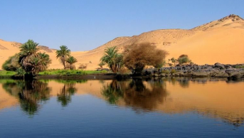
The Meric transboundary basin, is one of the major river systems located in the south-eastern Balkans, with a total length of around 550 km and a catchment area of 39,000 km⊃2;. The three main tributaries are Arda, Tundja (Tunca) and Ergene. Whereas about 66% of the basin territory belongs to Bulgaria, 28% belongs to Turkey and 6% belongs to Greece. 203 km of the river forms Turkey-Greece border. The Meric delta area is a significant ecological site, protected under the RAMSAR Convention.The mean discharge of the river is about 1,610 m⊃3;/sec in the mouth of the river. Water is mainly used for irrigation and drinking water supply, followed by steadily increasing industrial water use. Around three million people live throughout the basin, while around one million inhabitants live in sub-basin belonging to Turkey. The Meric Delta includes the coastal lakes, creeks, lagoons and provides shelter for a diversity of habitats. The river is un-navigable and mainly used for power production -particularly by Bulgaria- and irrigation.
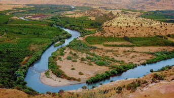
The Meric-Ergene is a sub-basin of Meric river system which is situated at the north-west part of Turkey. Basin’s territories entirely belong to Thrace[2]. The western boundaries of the basin are also international boundaries between Bulgaria and Turkey, and between Greece and Turkey. Istanbul, the most urbanized and industrialized city in Turkey comprise the eastern boundary of the basin. In the South, there is the Aegean Sea; in the south-east there is Marmara Sea (an inland sea of Turkey); and in the north, there lies the Black Sea.
In terms of water potential, the region has 8.6% of surface water potential in the country (approx. 9.5 billion cubic meters), and 3% of groundwater potential in the country (approx. 392 million cubic meters). Meric supplies the ¾ of surface waters in the basin.
4% of the total agricultural lands of Turkey are within the Meric-Ergene basin. Nearly 95% of the lands in the basin are arable. Furthermore, the agricultural productivity in the region is relatively high. Within this framework, as Gunduz (2006) notes 7.7% of wheat, 75% of sunflower and 45% rice produced in the country come from Meric-Ergene basin.
First systematic water management activities in the basin started with the establishment of Chief Engineering Office (Basmuhendislik) in Edirne, operating under the DSI I. General Directorate (Bursa) in 1955. In 1960, it is turned into a separate General Directorate of DSI (DSI XI. General Directorate). From then on, water development works gained momentum and a great number of regulators, reservoirs, dams and irrigation networks are constructed. However, environmental concerns that have been arisen due to rapid industrialization in the river basin brought about new priorities which sometimes run contradictory to early “water resources development” focus.
From the water-sensitive lenses, the Meric-Ergene basin could exemplify many problems that Turkish water policies experience and could be considered as a “microcosm” of Turkey’s water management. Consequently, evaluating the water problems faced in Meric-Ergene basin, and the solutions utilized to overcome these problems could also be a framework of analysis for water management concerns in Turkey, too.
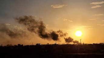
First of all, the basin has a transboundary component as Meric and its two main tributaries (Tunca and Arda) originate in Bulgaria. Secondly, the problem of water quality is a grave concern in the region due to several reasons mainly including high rate of population increase, expansion of Istanbul’s industry to the basin, lack of enough treatment capacities for industrial and urban wastewater. Third, due to increases in water needs of industries, domestic and particularly agricultural sector, renewable water capacity of the Meric-Ergene basin is exceeded, and thus there appeared a growing water deficit. The basin is an important agricultural production area. This agriculture, consider rice cultivation, for instance, relies on extensive water use. Therefore, there is the issue of irrigation and concomitant problems (efficient use of water, drainage, water pricing, over-exploitation of groundwaters etc.). Fourth, the basin is one of the most flood prone regions in the country. It appears to be one of the constant items in the agendas of authorities and people living on the banks of Meric River. The problem reaches out of the boundaries of Turkey; it needed and still needs a “transboundary” attention. Fifth, the region hosts a number of sensitive areas which are crucial for the health of the ecosystems and biodiversity, which also has an international dimension.
[1] ”Maritza” in Bulgarian, “Evros” in Greek.
[2] Geographically, Turkish territories lying in Europe are called as Thrace (“Trakya” in Turkish). “Meric-Ergene Basin”, as used in this article, is to mean Turkish part of the basin.